Fire Hazard Severity Zones Explained for LA County Land
Updated 2026-10-18
CAL FIRE rates land as Moderate, High or Very High fire hazard. A Very High zone means the seller has to disclose it, the lot has to be kept clear of brush, and a new home has to meet wildfire building rules. Of the 168,666 vacant lots in Los Angeles County, 56,443 (33%) are in a Very High zone and 59,627 are in some fire hazard zone.
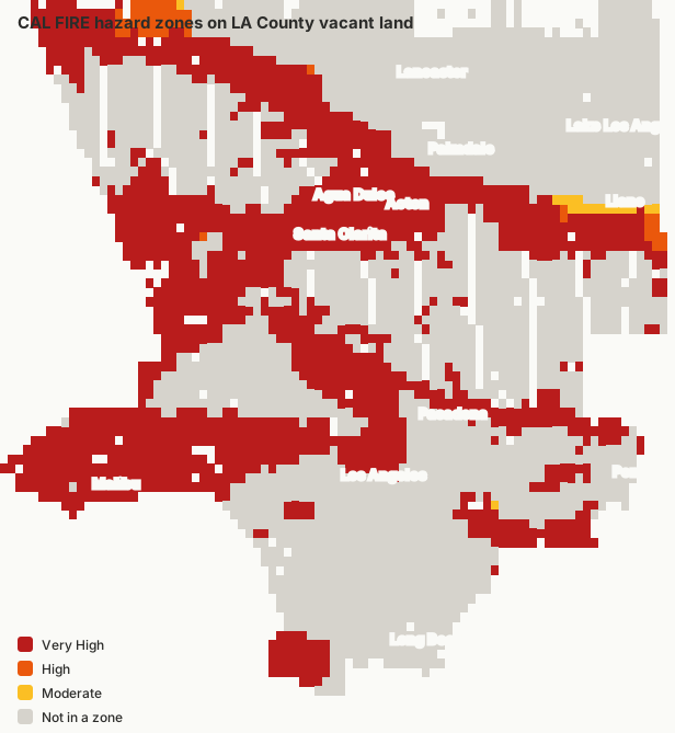
What is a fire hazard severity zone?
A fire hazard severity zone (FHSZ) is an area CAL FIRE rates as Moderate, High or Very High fire hazard, based on vegetation, slope, weather and fire history over the next 30 to 50 years. It measures how dangerous the land is, not the chance of a fire on one lot, and it is not an insurance rating.
| Zone | LA County vacant lots | Share |
|---|---|---|
| Very High | 56,443 | 33% |
| High | 1,184 | under 1% |
| Moderate | 2,000 | 1% |
| Not in a zone | 109,017 | 65% |
What are SRA and LRA zones?
A State Responsibility Area (SRA) is land where the state pays for wildfire protection, mostly unincorporated hills and desert. A Local Responsibility Area (LRA) is protected by a city or county fire department. CAL FIRE maps hazard zones in both; cities and counties adopt the LRA maps by ordinance.
CAL FIRE updated the state-area maps in 2024 and released new local-area maps in 2025, which added many neighborhoods inside cities. If a lot's zone looks new, that is probably why. LandGrab uses CAL FIRE's combined map for real estate disclosure, which covers both.
What does a Very High fire zone mean for a land buyer?
The seller must disclose it, the lot must be kept cleared of vegetation (defensible space), and any new home must be built to California's wildfire building standards. Insurance on a new home is usually harder to find and more expensive. In more detail:
- Disclosure. The seller's Natural Hazard Disclosure statement has to say the property is in a fire hazard severity zone.
- Defensible space. Owners must clear flammable vegetation around buildings, up to 100 feet. When a property with a building in a High or Very High zone is sold, the seller has to provide proof of a defensible space inspection (California Civil Code 1102.19, in effect since July 2021).
- Building rules. New buildings must follow the wildfire chapter of the California Building Code (Chapter 7A): ignition-resistant roofing and siding, ember-resistant vents and tempered glass. Budget for it.
- Insurance. Insurers price wildfire risk, so get home insurance quotes for the lot before you buy, not after.
Can you build on land in a Very High fire hazard zone?
Yes. Much of Acton, Agua Dulce and the foothills is Very High, and people build there every year. Expect the wildfire building standards above, fire department review of access and water supply for firefighting, and a road wide enough for fire trucks. Steep lots and lots at the end of long dirt roads cost the most to make compliant.
How do I find my fire zone by address?
The official source is the Office of the State Fire Marshal's fire hazard severity zone map viewer: search an address and it shows the zone. For a vacant lot, enter its APN in the box above, or open its LandGrab parcel page, where the CAL FIRE zone is near the top.
What is Zone 0, the 5-foot rule?
California is adding an "ember-resistant zone" to its defensible space rules: the first 5 feet around a building, where nothing that burns (wood mulch, plants, fences touching the house) should sit. The law creating it (AB 3074, 2020) applies in fire hazard severity zones, and the Board of Forestry and Fire Protection is writing the detailed rules. Check CAL FIRE's defensible space page for what is in force when you build.
What areas of LA County are safest from wildfire?
By CAL FIRE's map, the flat valley floors and the open desert. Of the areas with at least 500 vacant lots, these have the smallest share of land in any fire hazard zone:
| City or area | Vacant lots | In a fire zone |
|---|---|---|
| Roosevelt | 8,230 | 0% |
| Hi Vista | 4,848 | 0% |
| Redman | 4,537 | 0% |
| Butte Valley | 3,707 | 0% |
| Caliche | 3,300 | 0% |
| Alpine Butte | 2,344 | 0% |
| Sun Village | 2,845 | under 1% |
| Antelope Acres | 6,464 | under 1% |
A hazard zone is about the land around a lot, not a promise: wind-driven fires have burned into neighborhoods outside the zones.
Which LA County areas have the most land in Very High fire zones?
| City or area | Vacant lots | Very High | Share |
|---|---|---|---|
| Acton | 1,851 | 1,846 | 100% |
| Mount Waterman | 3,054 | 1,774 | 58% |
| Palmdale | 4,732 | 1,168 | 25% |
| Los Angeles | 5,480 | 1,026 | 19% |
| Agua Dulce | 978 | 969 | 99% |
| Juniper Hills | 914 | 913 | 100% |
| Del Sur | 3,526 | 872 | 25% |
| Pearblossom | 1,447 | 762 | 53% |
| Green Valley | 687 | 686 | 100% |
| Santa Clarita | 617 | 559 | 91% |
| Elizabeth Lake | 559 | 559 | 100% |
| Malibu | 479 | 467 | 97% |
| Leona Valley | 451 | 451 | 100% |
| Foothill | 457 | 405 | 89% |
| Anaverde | 396 | 377 | 95% |
| Sawmill Mountain | 397 | 368 | 93% |
| Lake Hughes | 329 | 327 | 99% |
| Elizabeth Lk | 285 | 285 | 100% |
| Littlerock | 796 | 234 | 29% |
| Gorman | 241 | 228 | 95% |
Each city page lists lots inside and outside fire hazard zones. See also the flood zone guide.
Sources
- Office of the State Fire Marshal: Fire Hazard Severity Zones
- CAL FIRE: Defensible space
- California Civil Code 1102.19
Counts are LandGrab's analysis of 2026 public data for vacant parcels in Los Angeles County, updated 2026-10-18. Maps change; confirm a specific lot with the county before you buy.